What's new

Welcome to Offtopix 👋, Visitor

Off Topix is a well-established general discussion forum that originally opened to the public in 2009! We provide a laid-back atmosphere, and our members are down to earth. We have a ton of content, and fresh stuff is constantly being added. We cover all sorts of topics, so there's bound to be something inside to pique your interest. We welcome anyone and everyone to register and become a member of our awesome community.

Join Our Facebook Page Today!

Join the conversation and help spread the word about offtopix on Facebook! Your voice matters—let’s make an impact together!

Join Our X.com Page Today!

Join the conversation and become a champion for Offtopix on X.com! Your voice is powerful, and together, we can create meaningful change!

Join offtopix Discord Server Today!

Join the conversation and become a champion for Offtopix on Discord! Your voice holds incredible power, and together, we can create impactful change!

New York Public Library Puts 20,000 Hi-Res Maps Online & Makes Them Free to Download

Jazzy

Waiting....
Valued Member
Joined
Jan 27, 2010
Posts
71,573
Reaction score
1,221
Points
2,125
Location
State Of Confusion
Website
wober.net
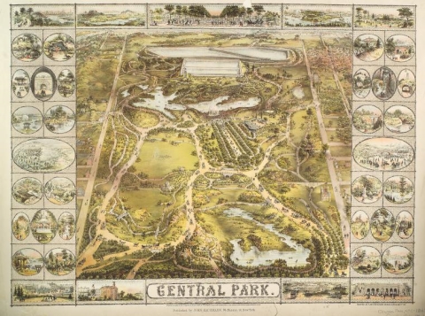
1863CentralPark.jpg


Whether you’re like me and simply love the imaginative exercise of tracing a map’s lines and contours and absorbing information, or you love to do that and you get paid for it, you’ll find innumerable ways to spend your time on the new Open Access Maps project at the New York Public Library. The NYPL announces the release with the explanation below:

The Lionel Pincus & Princess Firyal Map Division is very proud to announce the release of more than 20,000 cartographic works as high resolution downloads. We believe these maps have no known US copyright restrictions.* To the extent that some jurisdictions grant NYPL an additional copyright in the digital reproductions of these maps, NYPL is distributing these images under a Creative Commons CC0 1.0 Universal Public Domain Dedication. The maps can be viewed through the New York Public Library’s Digital Collections page, and downloaded (!), through the Map Warper.

What does this mean? Simply put, “it means you can have the maps, all of them if you want, for free, in high resolution.” Maps like that above, of New York’s Central Park, issued in 1863, ten years before Frederick Law Olmstead and Calvert Vaux completed their historic re-design.

Full article
 

Create an account or login to post a reply

You must be a member in order to post a reply

Create an account

Create an account here on Off Topix. It's quick & easy!

Log in

Already have an account? Log in here.

Welcome to Offtopix 👋, Visitor

Off Topix is a well-established general discussion forum that originally opened to the public in 2009! We provide a laid-back atmosphere, and our members are down to earth. We have a ton of content, and fresh stuff is constantly being added. We cover all sorts of topics, so there's bound to be something inside to pique your interest. We welcome anyone and everyone to register and become a member of our awesome community.

Theme customization system

You can customize some areas of the forum theme from this menu.

  • Theme customizations unavailable!

    Theme customization fields are not available to you, please contact the administrator for more information.

  • Choose the color combination that reflects your taste
    Background images
    Color gradient backgrounds
Back