- Joined
- Jul 22, 2014
- Posts
- 6,580
- Reaction score
- 301
- Points
- 1,075
Polar vortex to unleash record-breaking cold in eastern U.S. on Thursday, Friday

The coldest outbreak of the season is pushing south into the eastern United States this week. Temperatures will be running as low as 30 to 40 degrees below normal across the Ohio Valley and Mid-Atlantic on Friday morning. Thursday night’s departure from normal temperatures is shown above in Celsius. (tropicaltidbits.com)
The coldest air of the season is surging south this week, leading up to what could be historic cold for parts of the eastern United States.
Thursday and Friday’s polar outbreak could set all-time February low records from Tennessee to Virginia. With a fresh coat of snow, Washington has the potential to dip below zero for the first time since 1994.
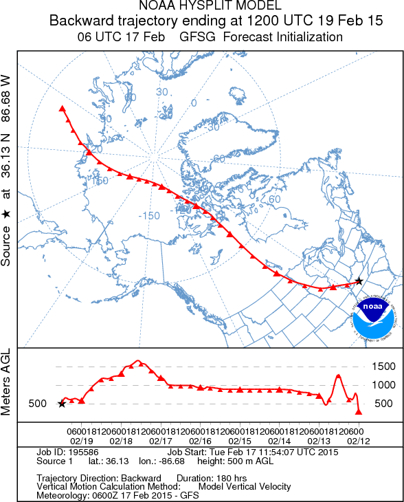
All of this is courtesy of a plume of not just Arctic, but Siberian air that has been trudging across the North Pole and into North America over the past week.

With the cold plume already washing over the northern Midwest on Wednesday, NOAA’s Weather Prediction Center suggests settling in for a dose of polar vortex:
Get ready for an even more impressive surge of arctic air later this week as another cold front drops south from Canada. There are indications that this could be some of the coldest weather since the mid-1990s for parts of the Southeast U.S., Mid-Atlantic, and central Appalachians. An eddy of the polar vortex will add to the potency of the surface cold front, thus creating a deep layer of bitterly cold air.
Thursday morning lows will dive below zero from the Midwest into the western Mid-Atlantic. Kentucky may wind up being the hardest hit by the Arctic blast, where temperatures will plummet to an astonishing 40 degrees below normal. Forecasts suggest that the entire state will be well below zero on Thursday morning, with some rural areas approaching minus 15 degrees.

Possible Friday morning lows as forecast by the GFS model. (weatherbell.com)
But if Thursday is bad, Friday will be much worse, when sub-zero temperatures dig in across the Midwest, the entire states of Ohio and West Virginia and east into the Mid-Atlantic. The GFS model is forecasting Friday morning lows below minus 20 degrees in parts of Michigan, Indiana, southern Ohio, Kentucky, West Virginia and far western Virginia.
Records for February low temperatures are in jeopardy in Cincinnati; Knoxville, Tenn.; Roanoke, Va., and Charleston, W.Va., says the Weather Channel.
While not everyone will see record-breaking lows this week, the entire eastern half of the United States will see below-average temperatures. When combined with winds, the outbreak will create dangerously cold wind chills on Thursday and Friday morning. Most of the eastern half of the country is painted with wind chill advisories and warnings from the Upper Midwest south into Florida.

Wind chill warnings and advisories are in effect across much of the eastern United States for Thursday and Friday. (National Weather Service)
------------------------------------------------------------------
Record Breaking New England Winter Storm Observed From Space

------------------------------------------------------------------


The coldest outbreak of the season is pushing south into the eastern United States this week. Temperatures will be running as low as 30 to 40 degrees below normal across the Ohio Valley and Mid-Atlantic on Friday morning. Thursday night’s departure from normal temperatures is shown above in Celsius. (tropicaltidbits.com)
The coldest air of the season is surging south this week, leading up to what could be historic cold for parts of the eastern United States.
Thursday and Friday’s polar outbreak could set all-time February low records from Tennessee to Virginia. With a fresh coat of snow, Washington has the potential to dip below zero for the first time since 1994.
All of this is courtesy of a plume of not just Arctic, but Siberian air that has been trudging across the North Pole and into North America over the past week.

With the cold plume already washing over the northern Midwest on Wednesday, NOAA’s Weather Prediction Center suggests settling in for a dose of polar vortex:
Get ready for an even more impressive surge of arctic air later this week as another cold front drops south from Canada. There are indications that this could be some of the coldest weather since the mid-1990s for parts of the Southeast U.S., Mid-Atlantic, and central Appalachians. An eddy of the polar vortex will add to the potency of the surface cold front, thus creating a deep layer of bitterly cold air.
Thursday morning lows will dive below zero from the Midwest into the western Mid-Atlantic. Kentucky may wind up being the hardest hit by the Arctic blast, where temperatures will plummet to an astonishing 40 degrees below normal. Forecasts suggest that the entire state will be well below zero on Thursday morning, with some rural areas approaching minus 15 degrees.

Possible Friday morning lows as forecast by the GFS model. (weatherbell.com)
But if Thursday is bad, Friday will be much worse, when sub-zero temperatures dig in across the Midwest, the entire states of Ohio and West Virginia and east into the Mid-Atlantic. The GFS model is forecasting Friday morning lows below minus 20 degrees in parts of Michigan, Indiana, southern Ohio, Kentucky, West Virginia and far western Virginia.
Records for February low temperatures are in jeopardy in Cincinnati; Knoxville, Tenn.; Roanoke, Va., and Charleston, W.Va., says the Weather Channel.
While not everyone will see record-breaking lows this week, the entire eastern half of the United States will see below-average temperatures. When combined with winds, the outbreak will create dangerously cold wind chills on Thursday and Friday morning. Most of the eastern half of the country is painted with wind chill advisories and warnings from the Upper Midwest south into Florida.

Wind chill warnings and advisories are in effect across much of the eastern United States for Thursday and Friday. (National Weather Service)
------------------------------------------------------------------
Record Breaking New England Winter Storm Observed From Space

------------------------------------------------------------------


