


Weather Channel: Tropical Storm Julia, A Flooding Hurricane Danger To Central America
Tropical Storm Julia will become a hurricane and inland flood threat to Central America this weekend into early next week.
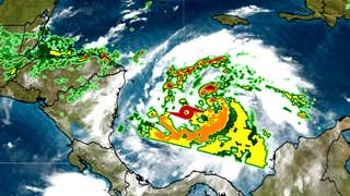
Julia became the tenth named storm of the 2022 Atlantic hurricane season late Friday morning, about two weeks later than the "J" storm arrives in an average season.
Julia is not expected to be a threat to the United States, but is a danger for Central America. Here's what you need to know.
Current Status, Watches, Warnings
Tropical Storm Julia is moving quickly west toward the Nicaraguan coast.
Hurricane warnings are now in effect for parts of the central Nicaraguan coast and for the Colombian islands of San Andres, Providencia and the Santa Catalina Islands near Nicaragua. This is where hurricane conditions are expected by Saturday evening, and tropical storm force winds could arrive this afternoon. A hurricane watch is now in effect along the Caribbean coast of Nicaragua from Puerto Cabezas north to the Honduran border. This means hurricane conditions are possible Sunday morning, with tropical storm force winds moving in by Saturday night.
Tropical storm warnings are in effect for much of the Caribbean coast of Nicaragua and watches for a part of the Honduras Caribbean coast from the border with Nicaragua to Punta Patuca. Tropical storm conditions are possible in this area Sunday morning. Tropical storm watches and warnings have also been issued for the Pacific coasts of El Salvador, Honduras and Nicaragua, where tropical storm conditions are possible in this area by late Sunday.
Julia's Threats
Heavy rain will be Julia's biggest threat over Central America beginning this weekend and lasting into next week as its remnant moves inland.
Parts of Nicaragua, Honduras, Costa Rica and Panama could pick up up to 15 inches of rain this weekend into early next week, according to the National Hurricane Center. This could trigger life-threatening flash flooding and landslides in areas of hilly or mountainous terrain.
Additional heavy rain will also spread into parts of Guatemala, Belize and southern Mexico which could also trigger flash flooding early next week. This rain may last well after Julia dissipates over Central America.
Where It's Headed And How Strong
Julia will organize and strengthen over the warm western Caribbean Sea under lighter wind shear. We expect Julia to become a hurricane later today.
High pressure aloft will expand westward, acting like a gate, keeping the system from entering the eastern Gulf of Mexico.
Therefore, we do not expect the system to pose a threat to the U.S. Gulf Coast. However, that high pressure aloft will steer Julia toward the coast of Central America, with a landfall expected most likely in Nicaragua. A small portion of the Nicaraguan coast will receive hurricane conditions close to this landfall.[/quote[